


Magic Earth Navigation & Maps

Description of Magic Earth Navigation & Maps
এমনকি ইন্টারনেট সংযোগ ছাড়াই আপনার গন্তব্যে যাওয়ার সেরা রুট খুঁজুন। ম্যাজিক আর্থ OpenStreetMap ডেটা এবং একটি শক্তিশালী সার্চ ইঞ্জিন ব্যবহার করে আপনাকে ড্রাইভিং, বাইক চালানো, হাইকিং এবং পাবলিক ট্রান্সপোর্টের জন্য সর্বোত্তম রুট অফার করে৷
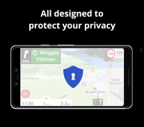
প্রথমে গোপনীয়তা!
• আমরা আপনাকে ট্র্যাক করি না। আমরা আপনাকে প্রোফাইল না. আমরা আপনার ব্যক্তিগত ডেটা ট্রেড করি না; তাছাড়া, আমাদের এটা নেই।
মানচিত্র
• মোবাইল ইন্টারনেট খরচে বড় সাশ্রয় করুন এবং OpenStreetMap দ্বারা চালিত অফলাইন মানচিত্রের সাথে নির্ভরযোগ্যভাবে নেভিগেট করুন৷ 233টি দেশ এবং অঞ্চল ডাউনলোড করার জন্য প্রস্তুত।
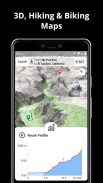
• 2D, 3D এবং স্যাটেলাইট ম্যাপ ভিউ এর মধ্যে বেছে নিন।
• ভ্রমণের জন্য প্রস্তুত হন এবং আপনার রুটের সমস্ত বিবরণ যেমন পৃষ্ঠ, অসুবিধা, দূরত্ব এবং উচ্চতার প্রোফাইল জানুন।
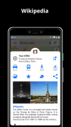
• উইকিপিডিয়া নিবন্ধগুলি থেকে আপনার কাছাকাছি আগ্রহের বিষয়গুলি সম্পর্কে আরও জানুন।
• সহজেই আপনার গাড়ি পার্ক করার জন্য কাছাকাছি পার্কিং স্থানগুলি চিহ্নিত করুন৷
• আপ টু ডেট থাকুন এবং নিয়মিত বিনামূল্যে মানচিত্র আপডেট উপভোগ করুন৷
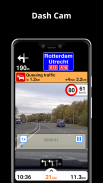
AI DASHCAM
• নিরাপদ ড্রাইভিং উন্নত করুন এবং দুর্ঘটনা এড়ান। রাস্তায় সম্ভাব্য সমস্যা সম্পর্কে সতর্কতা গ্রহণ করুন এবং আপনার ট্রিপ রেকর্ড করুন।
• এআই ড্যাশক্যামে ড্রাইভার সহায়তা সতর্কতা এবং ড্যাশ ক্যামের কার্যকারিতা রয়েছে৷
• ড্রাইভার সহায়তা সতর্কতা সহ সংঘর্ষ এবং দুর্ঘটনা এড়ান: হেডওয়ে সতর্কতা, সামনের সংঘর্ষের সতর্কতা, পথচারীদের সংঘর্ষের সতর্কতা, লেন প্রস্থান সতর্কতা, লেন ছেড়ে যাওয়ার সতর্কতা, থামুন এবং সহায়তা করুন।
• ন্যাভিগেশনের সময় সামনের রাস্তা রেকর্ড করুন যাতে সংঘর্ষ বা ঘটনার সময় সাহায্য পাওয়া যায়।
• ড্রাইভার সহায়তা সতর্কতা এবং রেকর্ডিংগুলি উপলব্ধ থাকে যখন ডিভাইসটি ল্যান্ডস্কেপ মোডে গাড়ি মাউন্টে থাকে, সামনের রাস্তার একটি পরিষ্কার দৃশ্য সহ।
* এআই ড্যাশক্যাম (ড্রাইভার সহায়তা সতর্কতা এবং ড্যাশ ক্যাম কার্যকারিতা সহ) অ্যান্ড্রয়েড 7 বা তার পরবর্তী সংস্করণ প্রয়োজন৷
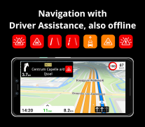
নেভিগেশন
• আপনি যখন গাড়ি, বাইকে, পায়ে হেঁটে বা পাবলিক ট্রান্সপোর্টে ভ্রমণ করেন তখন আপনার গন্তব্যের দ্রুততম বা সংক্ষিপ্ততম রুটটি খুঁজুন৷
• একাধিক ওয়েপয়েন্ট দিয়ে আপনার রুট পরিকল্পনা করুন।
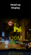
• ফ্রি হেড-আপ ডিসপ্লে (HUD) বৈশিষ্ট্যের সাথে নিরাপদ থাকুন যা আপনার গাড়ির উইন্ডশীল্ডে সবচেয়ে গুরুত্বপূর্ণ নেভিগেশন তথ্য প্রজেক্ট করে৷
• সুনির্দিষ্ট টার্ন-বাই-টার্ন নেভিগেশন এবং লেন সহায়তার সাথে কোন লেনটি নিতে হবে তা আগে থেকেই জেনে নিন।
• স্পিড ক্যামেরা সম্পর্কে বিজ্ঞপ্তি পান এবং বর্তমান গতি সীমার সাথে আপ টু ডেট থাকুন।
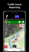
ট্রাফিক তথ্য
• রিয়েল-টাইম ট্রাফিক তথ্য পান, প্রতি মিনিটে আপডেট করা হয়।
• বিকল্প রুট আবিষ্কার করুন যা যানজট এড়ায় এবং রাস্তায় আপনার সময় বাঁচায়।
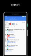
পাবলিক ট্রান্সপোর্ট
• দ্রুত এবং সহজে শহরের কাছাকাছি যান। পাবলিক ট্রানজিট রুটগুলি থেকে বেছে নিন যা সমস্ত পরিবহন মোডকে একত্রিত করে: বাস / মেট্রো / পাতাল রেল / হালকা রেল / ট্রেন / ফেরি
• হাঁটার দিকনির্দেশ, স্থানান্তরের সময়, প্রস্থানের সময়, স্টপের সংখ্যা পান। এবং যখন উপলব্ধ, খরচ.
• হুইলচেয়ার বা সাইকেল বান্ধব পাবলিক পরিবহন খুঁজুন।
আবহাওয়া
• আপনার প্রিয় অবস্থানের জন্য বর্তমান তাপমাত্রা এবং স্থানীয় আবহাওয়ার পূর্বাভাস দেখুন।
• পরবর্তী ঘন্টাগুলিতে কী আবহাওয়ার আশা করা যায় তা দেখুন এবং পরবর্তী 10 দিনের পূর্বাভাস দেখুন৷
মন্তব্য:
* কিছু বৈশিষ্ট্য সব দেশে উপলব্ধ নয়।
* কিছু বৈশিষ্ট্য ইন্টারনেট সংযোগ প্রয়োজন.
Magic Earth Navigation & Maps - Version 7.1.25.11.152F252F.3F8D5820
(22-03-2025)
Magic Earth Navigation & Maps - APK Information
APK Version: 7.1.25.11.152F252F.3F8D5820Package: com.generalmagic.magicearthLatest Version of Magic Earth Navigation & Maps
Other versions


Apps in the same category


